


Morning after the break fast cross the river and entre in to the velly through a rough motorable road. After walking for a few minutes cross the river to the left and walk in some direction. cross another tributries coming from the right side.walk throught the some velly finally you truns to the norht and the camp site. next to sephards place.
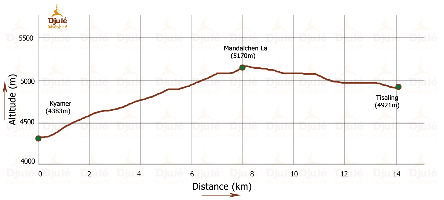
After a few minutes walk from the campsite the ascent of kyumur la stars its easy but very long way to reach the top. there are beautiful flowers on the way. from the top of the pass the trail divides in to two one goes to your left which leads towards same destination but one day longer.
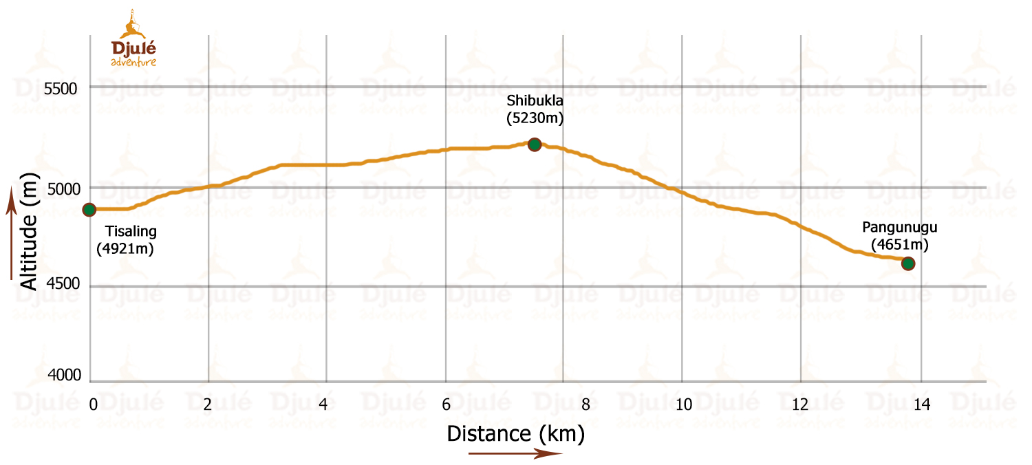
you can take the trail falls on your right hand side. which goes down to stream and start climbing another pass across the stream. there is no trail to be seen for sometimes. but after few minutes, a clear trailleads you to the topof mandalchan la 4996m. the trail goes further up and then steep down ot a beautiful area called Tisaling. pitch your tent here near the stream.
Today you have to cross shibukla near the camp site. there are two hill saddle, so you have cross right saddle . as soon as you come on the top of the pass yuo can have view of tsokar lake. walk down the to tsokar lake through as easy decent through the velly.as soo as finish the velly walk through the hill as the camp site is just behind the hill.
Today its an easy walk along the lake. motorable road nad take the some direction from the end of stupa along the road. after sometime you can have view of Agriculture field. and the 4712m. 3/4 hrs.camp site is just next to the field near the river.

As easy ascend to the pass takes around i hours 30 minutes. the trailtruns towards north east just after crossing the pass through the velly. the camp site is across the river at the base of the kyamayurla pass.

As easy ascend to the pass takes around i hours 30 minutes. the trail truns towards north east just after crossing the pass through the valley. the camp site is acStart climbing kyamayur la pass 5125m as soon azs you leave your campwhich takes around 2hrs. at average speed. the last climb is tiring one . after the pass the trail leads towards north east and at the end of the velly trail start ascending another small pass called gyamaila 5100m from where you can have view of a group of peaks.walk down towards north east and cross a small river ross the river at the base of the kyamayurla pass.

Start an easy ascent to the korzok pass along the stream.it takes around 2 hrs to reach the top from where you can have wondeful view of the lake. then steep down to korzok village. you can also camps are lake if you have extra days.one day rest.

Today it is easy walk along the lake towards south east.the camp site is just at the end of the lake.

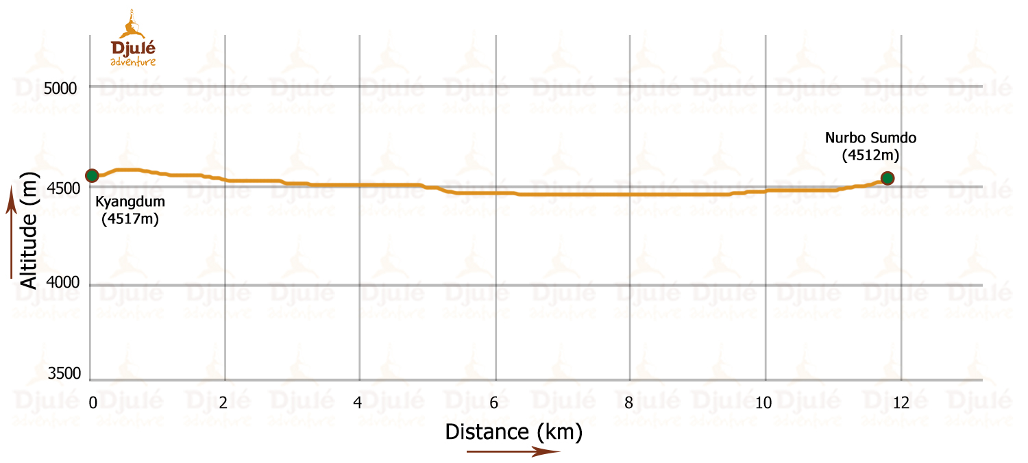
As soon as you leave kyangdam cross the river and walk towards east through a plain ground .after two hours walk you will see a spring water walk to the same direction leaving camp site behind and the just cross the river.
Today it is again an easy walk along the parangchu to the south. the camp site is just before up.and down.

Walk towards the same direction passing through several up down and the camp site is after crossing a tributries coming from the east.
Today it is an easy walk .WALK TO THE SAME DIRECTION TILL A HUGE ROCK FROM WHERE you have to cross the river to the right . walk ahead to the base of parang la.

Today you have to cross the parang la pass through the glacier. walk from left side of the glacier. through the foot hill till the caravas becomes very narrow or finishes and walk towardssouth to the top of the pass. the pass has prayer flages and an other side is dry and very steep down. Walk down to the river it is called parangchu]and walk to wards east along the river through a narrow gorge3.the camp site is reach up the hillwhich have spring water at the campsite.

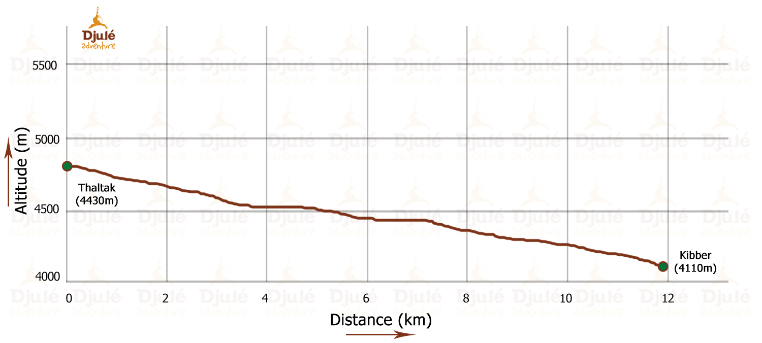
Walk towards east and you can have view of kibbervillagejust after a small pass across the river .and have a luch kibber village on the way visit key gonpa. overnight hotel at kaza.